| San Gabriel Dam | |
|---|---|
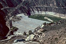
 The dam seen from Glendora Mountain Road | |
| Country | United States |
| Location | Los Angeles County, California |
| Coordinates | 34°12′20″N 117°51′33″W / 34.20556°N 117.85917°W |
| Construction began | 1932 |
| Opening date | 1939 |
| Construction cost | $17 million |
| Owner(s) | Los Angeles County Flood Control District |
| Dam and spillways | |
| Type of dam | Rock-fill |
| Impounds | San Gabriel River |
| Height | 315 ft (96 m) |
| Length | 1,520 ft (460 m) |
| Spillway type | Ungated overflow |
| Reservoir | |
| Creates | San Gabriel Reservoir |
| Total capacity | 44,183 acre⋅ft (54,499 dam3) |
| Catchment area | 205 sq mi (530 km2) |
| Surface area | 525 acres (212 ha) |
| Power Station | |
| Operator(s) | City of Azusa |
| Commission date | 1940 |
| Installed capacity | 3 MW |
| Annual generation | 4,464,000 KWh |
San Gabriel Dam is a rock-fill dam on the San Gabriel River in Los Angeles County, California, within the Angeles National Forest. Completed in 1939, the dam impounds the main stem of the San Gabriel River about 2.5 miles (4.0 km) downstream from the confluence of the river's East and West Forks, which drain a large portion of the San Gabriel Mountains. It is located directly upstream from the Morris Dam. The dam provides flood control, groundwater recharge flows and hydroelectricity for the heavily populated San Gabriel Valley in the Greater Los Angeles metropolitan area.