| San Joaquin Hills | |
|---|---|
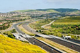
 State Route 73 climbs into the San Joaquin Hills, as seen looking southward from University Hills, Irvine | |
| Highest point | |
| Peak | Temple Hill (California) |
| Elevation | 1,050 ft (320 m) |
| Geography | |
location of San Joaquin Hills in California[1] | |
| Country | United States |
| State | California |
| Region | Peninsular Ranges |
| District | Orange County |
| Range coordinates | 33°36′42.081″N 117°48′33.198″W / 33.61168917°N 117.80922167°W |
| Borders on | Santa Ana Mountains |
| Topo map | USGS Laguna Beach |
The San Joaquin Hills are a low mountain range of the Peninsular Ranges System, located in coastal Orange County, California.[1]
They extend in a northwest–southeast direction, starting in the northwest in Newport Beach at the southern edge of the Los Angeles Basin, and extending southeast to San Juan Capistrano.
- ^ a b "San Joaquin Hills". Geographic Names Information System. United States Geological Survey, United States Department of the Interior. Retrieved 2009-05-04.

