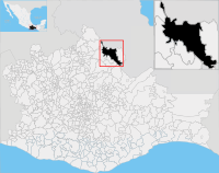
San Juan Bautista Tuxtepec | |
|---|---|
Municipality and city | |
 | |
 San Juan Bautista Tuxtepec in Oaxaca | |
| Coordinates: 18°06′N 96°07′W / 18.100°N 96.117°W | |
| Country | |
| State | Oaxaca |
| Municipality | San Juan Bautista Tuxtepec |
| Founded | C. 14th (?) |
| Municipality created | 1811 |
| Area | |
| • Total | 877 km2 (339 sq mi) |
| • Municipal Seat | 41.92 km2 (16.19 sq mi) |
| Elevation | 20 m (70 ft) |
| Population (2020 census)[1] | |
| • Total | 159,452 |
| • Density | 180/km2 (470/sq mi) |
| • Municipal Seat | 103,609 |
| • Municipal Seat density | 2,500/km2 (6,400/sq mi) |
| Time zone | UTC-6 (Central (US Central)) |
| • Summer (DST) | UTC-5 (Central) |
| Postal code | 68300 (Centro)[2] |
| Area code | 287[3] |
| Fiestas | 23–24 June |
| Website | http://www.tuxtepec.gob.mx/ |
San Juan Bautista Tuxtepec (Nahuatl languages: Tōchtepēc, "on the hill of rabbits"), or simply referred to as Tuxtepec, is the head of the municipality by the same name and is the second most populous city of the Mexican state of Oaxaca. It is part of the Tuxtepec District of the Papaloapan Region. As of the 2020 census, the city is home to a population of 103,609 and 159,452 in the municipality (0.979% of the state population), though census data are often under reported for various reasons.
- ^ Citypopulation.de Population of San Juan Bautista Tuxtepec municipality with localities
- ^ "Búsqueda, mostrando resultados para: San Juan Bautista Tuxtepec". micodigopostal.org. Retrieved August 26, 2020.
- ^ Pérez-Lustre, Martín; Díaz, Rusby Guadalupe Contreras; Moreno, Antonio Santos (1 January 2006). "Mamíferos del bosque mesófilo de montaña del Municipio de San Felipe Usila, Tuxtepec, Oaxaca, México" [The cloud forest mammals of the Municipality of San Felipe Usila, Tuxtepec, Oaxaca, México]. Revista Mexicana de Mastozoología (Nueva época). 10 (1): 29–40. doi:10.22201/ie.20074484e.2006.10.1.140. Retrieved August 26, 2020.

