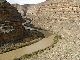
| San Juan River Są́ bito' (in Navajo) | |
|---|---|
 The lower San Juan River, Utah | |
 Map of the San Juan River watershed | |
| Location | |
| Country | United States |
| States | Colorado, New Mexico, Utah |
| Physical characteristics | |
| Source | San Juan Mountains |
| • location | Archuleta County, Colorado |
| • coordinates | 37°21′55″N 106°54′02″W / 37.36528°N 106.90056°W[1] |
| • elevation | 7,553 ft (2,302 m) |
| Mouth | Colorado River (Lake Powell) |
• location | San Juan County, Utah |
• coordinates | 37°10′47″N 110°54′03″W / 37.17972°N 110.90083°W[1] |
• elevation | 3,704 ft (1,129 m) |
| Length | 383 mi (616 km)[2] |
| Basin size | 24,649 sq mi (63,840 km2)[3] |
| Discharge | |
| • location | Bluff, Utah, about 113.5 mi (182.7 km) from the mouth[4] |
| • average | 2,152 cu ft/s (60.9 m3/s)[4] |
| • minimum | 0 cu ft/s (0 m3/s) |
| • maximum | 70,000 cu ft/s (2,000 m3/s) |
| Basin features | |
| Tributaries | |
| • left | Navajo River, Chaco River, Chinle Creek |
| • right | Piedra River, Los Pinos River, Animas River, Mancos River |
The San Juan River is a major tributary of the Colorado River in the Southwestern United States, providing the chief drainage for the Four Corners region of Colorado, New Mexico, Utah, and Arizona. Originating as snowmelt in the San Juan Mountains (part of the Rocky Mountains) of Colorado, it flows 383 miles (616 km)[2] through the deserts of northern New Mexico and southeastern Utah to join the Colorado River at Glen Canyon.
The river drains a high, arid region of the Colorado Plateau. Along its length, it is often the only significant source of fresh water for many miles. The San Juan is also one of the muddiest rivers in North America, carrying an average of 25 million US tons (22.6 million t) of silt and sediment each year.[5]
Historically, the San Juan formed the border between the territory of the Navajo in the south and the Ute in the north. Although Europeans explored the Four Corners region as early as the 1700s, it was not settled until the gold and silver booms of the 1860s, when settlers arrived in large numbers from the eastern United States. After heated conflicts over land, the Native Americans were forced into reservations, where their descendants live today.
During the 20th century, intensive drilling in the fossil-fuel rich San Juan Basin and uranium mining along the lower river in Utah generated serious concerns about water quality, particularly in the Navajo Nation where the river is a crucial source of water for irrigation. Runoff from abandoned gold and silver mines has also been a major issue, as occurred in the 2015 Gold King Mine waste water spill into the Animas River, the main tributary of the San Juan.
The U.S. federal government has built a number of large dams in the San Juan River system to control floods and to provide irrigation and domestic water supply. In addition, the lower part of the river is inundated by Lake Powell, one of the largest reservoirs in the United States. Efficient management is crucial to ensuring enough water supply not just for farms and urban areas but also for recreational boating, fisheries, and environmental restoration. However, heavy water use has significantly reduced the flow of the San Juan River by as much as 25 percent since pre-development conditions. In addition, warming temperatures in the Rocky Mountains are projected to have a further negative effect on snowpack and thus stream flow.
- ^ a b "San Juan River". Geographic Names Information System. United States Geological Survey, United States Department of the Interior. 1979-12-31. Retrieved 2017-05-15.
- ^ a b U.S. Geological Survey. National Hydrography Dataset high-resolution flowline data. The National Map, accessed March 21, 2011
- ^ "Boundary Descriptions and Names of Regions, Subregions, Accounting Units and Cataloging Units". United States Geological Survey. Retrieved 2017-05-15.
- ^ a b "USGS Gage #09379500 San Juan River near Bluff, Utah: Water-Data Report 2013" (PDF). National Water Information System. U.S. Geological Survey. 2013. Retrieved 2017-05-15.
- ^ Cite error: The named reference
Thompsonwas invoked but never defined (see the help page).