| San Luis Dam | |
|---|---|
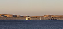
 View of San Luis Dam and the intake structure. | |
| Country | United States |
| Location | Merced County, California |
| Coordinates | 37°03′33″N 121°04′29″W / 37.05917°N 121.07472°W[1] |
| Construction began | 1963 |
| Opening date | 1968 |
| Owner(s) | U.S. Bureau of Reclamation and California Department of Water Resources |
| Dam and spillways | |
| Type of dam | Embankment |
| Height (foundation) | 382 ft (116 m)[2] |
| Length | 18,600 ft (5,700 m)[2] |
| Dam volume | 77,656,000 cu yd (59,372,000 m3)[3] |
| Reservoir | |
| Creates | San Luis Reservoir |
| Total capacity | 2,041,000 acre⋅ft (2.518 km3)[3] |
| Catchment area | 82.6 sq mi (214 km2)[2] |
| Surface area | 12,700 acres (5,100 ha) |
| Normal elevation | 544 ft (166 m)[2] |
| William R. Gianelli Powerplant[4] | |
| Commission date | 1968[4] |
| Type | Pumping-generating |
| Hydraulic head | 323 ft (98 m) max[4] |
| Turbines | 8 x 53.0 MW Francis turbines[4] |
| Installed capacity | 424 MW[4] |
San Luis Dam, also known as B.F. Sisk Dam, is a major earth-filled dam in Merced County, California, which forms San Luis Reservoir, the largest off-stream reservoir in the United States.[citation needed] The dam and reservoir are located in the Diablo Range to the east of Pacheco Pass and about 10 miles (16 km) west of Los Banos. San Luis Dam, a jointly-owned state and federal facility, stores more than 2 million acre feet (2.5 km3) of water for the California State Water Project and the federal Central Valley Project. Although the dam is located in the valley of San Luis Creek, the majority of its water comes from man-made aqueducts which are supplied from other rivers in Northern California.
San Luis provides water mainly for irrigation in the San Joaquin Valley, where it augments the supply for more than 1 million acres (400,000 ha) of agricultural land, although some water is also used for urban and environmental uses. The dam was built between 1963 and 1968, and filled for the first time in 1969. It provides flexibility to the state water system by capturing, via pumps and canals, the wet season (November–April) runoff that would otherwise flow from the Sacramento–San Joaquin River Delta into the Pacific Ocean. It also generates hydroelectricity by releasing the water when it is needed. However, it has indirectly impacted the environment by enabling increased water diversion from sensitive estuary regions. In recent years, a combination of drought and pumping restrictions enacted to protect endangered fish have contributed to low water levels at the San Luis Reservoir.[5]
The dam and reservoir are visible from the Romero Overlook Visitors Center, which is located along Highway 152.[6]
- ^ "San Luis Dam". Geographic Names Information System. United States Geological Survey, United States Department of the Interior. January 19, 1981. Retrieved February 9, 2017.
- ^ a b c d Cite error: The named reference
San Luis Damwas invoked but never defined (see the help page). - ^ a b Cite error: The named reference
San Luis Unit Projectwas invoked but never defined (see the help page). - ^ a b c d e Cite error: The named reference
Gianelli Powerplantwas invoked but never defined (see the help page). - ^ Rogers, Paul (August 16, 2013). "San Luis Reservoir 17 percent full, causing Silicon Valley water problems". The Mercury News. Retrieved February 9, 2017.
- ^ "Locations: Romero Overlook Visitors Center (San Luis Reservoir)". California Department of Water Resources. Retrieved February 10, 2017.