San Pablo
Cabagan Viejo | |
|---|---|
| Municipality of San Pablo | |
 San Pablo de Cabagan Church Ruin | |
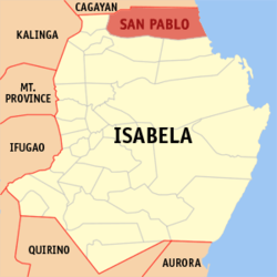
 Map of Isabela with San Pablo highlighted | |
Location within the Philippines | |
| Coordinates: 17°26′52″N 121°47′42″E / 17.4478°N 121.795°E | |
| Country | Philippines |
| Region | Cagayan Valley |
| Province | Isabela |
| District | 1st district |
| Established | January 1, 1910 (as San Pablo)[1] |
| Named for | St. Paul the Apostle[2] |
| Barangays | 17 (see Barangays) |
| Government | |
| • Type | Sangguniang Bayan |
| • Mayor | Antonio N. Miro, Jr. |
| • Vice Mayor | Antonio Jose T. Miro III |
| • Representative | Antonio T. Albano |
| • Electorate | 16,934 voters (2022) |
| Area | |
| • Total | 637.90 km2 (246.29 sq mi) |
| Elevation | 41 m (135 ft) |
| Highest elevation | 168 m (551 ft) |
| Lowest elevation | 14 m (46 ft) |
| Population (2020 census)[5] | |
| • Total | 26,320 |
| • Density | 41/km2 (110/sq mi) |
| • Households | 5,867 |
| Economy | |
| • Income class | 2nd municipal income class |
| • Poverty incidence | 19.47 |
| • Revenue | ₱ 203.9 million (2020) |
| • Assets | ₱ 494.9 million (2020) |
| • Expenditure | ₱ 144.3 million (2020) |
| • Liabilities | ₱ 88.74 million (2020) |
| Service provider | |
| • Electricity | Isabela 2 Electric Cooperative (ISELCO 2) |
| Time zone | UTC+8 (PST) |
| ZIP code | 3329 |
| PSGC | |
| IDD : area code | +63 (0)78 |
| Native languages | Ibanag Ilocano Tagalog |
| Website | www |
San Pablo, officially the Municipality of San Pablo (Ibanag: Ili nat San Pablo; Ilocano: Ili ti San Pablo; Tagalog: Bayan ng San Pablo), is a 2nd class municipality in the province of Isabela, Philippines. According to the 2020 census, it has a population of 26,320 people.[5]
San Pablo is 52 kilometres (32 mi) from Ilagan and 450 kilometres (280 mi) from Manila.
An editor has launched a copyright investigation involving this section. The text under investigation is currently hidden from public view, but is accessible in the page history. Please do not remove this notice or restore blanked content until the issue is resolved by an administrator, copyright clerk, or volunteer response agent.
The purported copyright violation copies text from https://provinceofisabela.ph/images/2018/History_of_Isabela/5-History%20of%20San%20Pablo%20Isabela.pdf ; as such, this page has been listed on the copyright problems page. Unless the copyright status of the text of this page or section is clarified and determined to be compatible with Wikipedia's content license, the problematic text and revisions or the entire page may be deleted one week after the time of its listing (i.e. after 13:32, 2 July 2024 (UTC)). What can I do to resolve the issue?
Steps to list an article at Wikipedia:Copyright problems:
|


