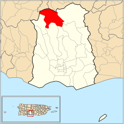
San Patricio | |
|---|---|
 | |
 Location of barrio San Patricio within the municipality of Ponce shown in red | |
| Coordinates: 18°08′10″N 66°38′34″W / 18.136037°N 66.642703°W[1] | |
| Commonwealth | |
| Municipality | |
| Area | |
| • Total | 6.85 sq mi (17.7 km2) |
| • Land | 6.85 sq mi (17.7 km2) |
| • Water | 0 sq mi (0 km2) |
| Elevation | 2,103 ft (641 m) |
| Population (2010) | |
| • Total | 564 |
| • Density | 82.3/sq mi (31.8/km2) |
| Source: 2010 Census | |
| Time zone | UTC−4 (AST) |
San Patricio is one of the 31 barrios of the municipality of Ponce, Puerto Rico. It is one of the municipality's nine bordering barrios, along with Anón, Coto Laurel, Guaraguao, Quebrada Limón, Real, and Marueño, and the coastal barrios of Canas and Capitanejo. Its northern edge borders the municipalities of Utuado and Jayuya. It was founded in 1878.[3] Barrio San Patricio is one of three Ponce barrios (the others are Barrio Guaraguao and Barrio Anón) located on the Cordillera Central mountain range.[4]
- ^ a b "US Gazetteer 2019". US Census. US Government.
- ^ U.S. Geological Survey Geographic Names Information System: San Patricio barrio
- ^ Ubeda y Delgado, Manuel. (1878). Isla de Puerto Rico: Estudio histórico, geográfico y estadístico de la misma. Cited in, Municipio de Ponce: Memoria Suplementaria al Mapa de Límites del Municipio y sus Barrios," (1953). Ponce, Puerto Rico: Planning Board. p.7. Accessed 3 March 2017.
- ^ Ponce: Topografía. Proyecto Salon Hogar. Accessed 13 March 2019.
