| San Rafael Swell | |
|---|---|
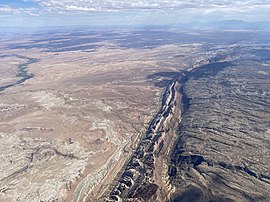
 The San Rafael Swell from 16,000 feet | |
| Highest point | |
| Coordinates | 38°48′47″N 110°51′18″W / 38.813°N 110.855°W |
| Dimensions | |
| Length | 75 mi (121 km) |
| Width | 40 mi (64 km) |
| Geography | |
| Location | Colorado Plateau, Utah, US |
The San Rafael Swell is a large geologic feature located in south-central Utah, United States about 16 miles (26 km) west of Green River. The San Rafael Swell, measuring approximately 75 by 40 miles (121 by 64 km), consists of a giant dome-shaped anticline of sandstone, shale, and limestone that was pushed up during the Paleocene Laramide Orogeny 40–60 million years ago. Since that time, infrequent but powerful flash floods have eroded the sedimentary rocks into numerous valleys, canyons, gorges, mesas, buttes, and badlands.
The swell is part of the Colorado Plateau physiographic region.
