Native name: Jazīrat Ṣanafir / جزيرة صنافر | |
|---|---|
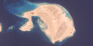
 The island from space | |
 | |
| Geography | |
| Location | Red Sea |
| Coordinates | 27°55′48″N 34°42′36″E / 27.93000°N 34.71000°E |
| Total islands | 1 |
| Area | 33 km2 (13 sq mi) |
| Highest elevation | 49 m (161 ft) |
| Administration | |
| Demographics | |
| Population | Uninhabited |
 | |
Sanafir Island (Arabic: جزيرة صنافر, romanized: Jazīrat Ṣanafir,[citation needed] pronounced [ɡeˈziːret sˤɑnɑˈfiːɾ]) is a Saudi island in the Straits of Tiran east of Tiran Island. It is about 33 km2 (13 sq mi) it is located at the entrance to the Straits of Tiran, which separates the Gulf of Aqaba from the Red Sea. The island is about 2.5 km from Tiran Island.[1] The island is characterized by floating coral reefs.[2]
The island was under Egyptian control in the past but reverted to Saudi Arabian sovereignty on 8 April 2016, after the completion of transfer procedures.[3] On 17 June 2017, Egyptian President Abdel Fattah el-Sisi ratified the maritime demarcation agreement between the two countries.[4][5] It was adopted on maps and official documents on 17 August 2017 and approved by the Egyptian House of Representatives on 14 June 2017, which approved the transfer of the island and its neighbor to Saudi Arabia. The United Nations was notified in accordance with the Charter of Article 102 of the provisions of subsidiarity and sovereignty relating to islands and maritime territory.[6]
- ^ Alfabet el-Loĝa l-Maṣri
- ^ الطبيعية (in Arabic). Ministry of Environment.
- ^ "The World Fact Book – Middle East – Saudi Arabia". Central Intelligence Agency. 5 April 2016. Retrieved 13 April 2016.
- ^ بالمستندات .. جزيرتي تيران وصنافير تابعان للمملكة العربية السعودية (in Arabic). Information and Decision Support Center. 12 April 2016. Retrieved 17 April 2016.
- ^ أشرف عبد حميد (11 April 2016). مصر تفرج عن وثائق تثبت تبعية "تيران" و"صنافير" للسعودية (in Arabic). Al Arabiya. Retrieved 13 April 2016.
- ^ "وثائق الحدود السعودية لدى الأمم المتحدة". الأمم المتحدة. Retrieved 5 July 2017.