Sandoy | |
|---|---|
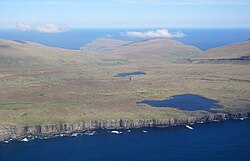
 Island of Sandoy seen from a helicopter. | |
 Location within the Faroe Islands | |
| Coordinates: 61°51′N 6°47′W / 61.850°N 6.783°W | |
| State | Kingdom of Denmark |
| Autonomous country | Faroe Islands |
| Region | Sandoy |
| Area | |
• Total | 125 km2 (48 sq mi) |
| Population (01-2020) | |
• Total | 1,231[1] |
| Time zone | UTC+0 (GMT) |
| • Summer (DST) | UTC+1 (EST) |
| Calling code | 298 |
Sandoy ("Sand Island") is the first of the five southern islands that make up the Faroe chain, the fifth biggest of all the Faroe Islands,[2] an autonomous region of the Kingdom of Denmark. It also refers to the region that includes this island along with Skúvoy and Stóra Dímun. As of January 2020[update], the largest population centre on the island is the village of Sandur with a population of 532.[3] Other settlements include Skarvanes, Skopun, Skálavík, Húsavík and Dalur.
Sandoy gets its name from the large beach at Sandur, and the general sandy soil of the island. It is the only island with dunes.
There are similarly named islands, Sanday in the Orkney Islands, Sanday in the Inner Hebrides and Sandøy in Norway.
The Sandoyartunnilin connects between the centre of the island and Gamlarætt on Streymoy. Construction started in 2019 and the tunnel opened for traffic on 21 December 2023.[4]
- ^ Statistical Database
- ^ Proctor, James (2008). Faroe Islands. Bradt Travel Guides. p. 133. ISBN 978-1-84162-224-8.
- ^ Hagstova. "Sandoy". Faroese Statistics Office. Retrieved 20 August 2020.
- ^ "Framgongd við boring". Eystur- og Sandoyatunlar. Retrieved 2020-08-20.