| Sandy Pond Beach Unique Area | |
|---|---|
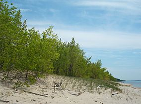
 South-facing view of the dunes along the Lake Ontario shore at Sandy Pond Beach in spring 2009. | |
| Location | Oswego County, New York, USA |
| Nearest city | Oswego, New York |
| Coordinates | 43°39′36″N 76°11′46″W / 43.66°N 76.196°W |
| Area | 76 acres (31 ha) |
| Established | 1994 |
| Visitors | 18,874[1] (in 2009) |
| Governing body |
|

Sandy Pond Beach Unique Area is a 76-acre (31 ha) New York State conservation area located within the eastern Lake Ontario dunes. It lies at the north end of a spit of land dividing North Sandy Pond from Lake Ontario, and is about two miles (3.2 km) north of the developed portion of Sandy Island Beach State Park.[2] There is no road access to the area, which can be most easily reached by boat. For this reason, local residents have long referred to the beach as "Boaters' Beach". It has been managed as part of Sandy Island Beach State Park since 2011.
- ^ Kuehn, Diane; Habig, Rachel (January 2010). "Monitoring Recreational Use in the Eastern Lake Ontario Dune and Wetland Area" (PDF). See Table 4, p. 17.
- ^ "Sandy Pond Beach Unique Area". New York State Department of Environmental Conservation. Archived from the original on July 26, 2010.
