This article needs additional citations for verification. (August 2017) |
Sangareddy
Sangareddipet | |
|---|---|
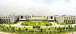
 Collectorate building of Sangareddy | |
| Coordinates: 17°37′46″N 78°05′30″E / 17.6294°N 78.0917°E | |
| Country | |
| State | Telangana |
| District | Sangareddy |
| Metro | Hyderabad Metropolitan Region |
| City | Hyderabad |
| Municipal Established | 1954 |
| Named for | Sanga |
| Government | |
| • Type | Municipal Council |
| • Body | Sangareddy Municipal Corporation |
| • MLA | Chinta Prabhakar |
| • District collector | Smt. Valluru Kranthi, IAS |
| Area | |
• City | 13.70 km2 (5.29 sq mi) |
| Elevation | 496 m (1,627 ft) |
| Population (2011)[1] | |
• City | 72,344 |
| • Rank | 21st in Telangana |
| • Density | 5,300/km2 (14,000/sq mi) |
| • Metro | 325,000 |
| Languages | |
| • Official | Telugu, Urdu |
| Time zone | UTC+5:30 (IST) |
| PIN | 502 001 |
| Telephone code | code-08455 |
| Vehicle registration | TG-15 |
Sangareddy, formerly Sangareddipet[2][3] is a city and district headquarters of the Sangareddy district in the Indian state of Telangana. It comes in the jurisdiction of Greater Hyderabad Municipal Corporation. It was named after the ruler Sanga, who was the son of Rani Shankaramba, a ruler of Medak during the Nizam era. It is the largest city in the Sangareddy district and the sixth largest city in the state.
- ^ a b "Urban Local Body Information" (PDF). Directorate of Town and Country Planning. Government of Telangana. Archived from the original (PDF) on 15 June 2016. Retrieved 28 June 2016.
- ^ Anirudh, Reddy (1922). "Composite: India". www.davidrumsey.com. Retrieved 20 August 2024.
- ^ "District Sangareddy, Government of Telangana | India".

