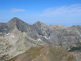
| Sangre de Cristo Mountains | |
|---|---|
 Blanca Peak | |
| Highest point | |
| Peak | Blanca Peak, East of Alamosa, Colorado |
| Elevation | 14,351 ft (4,374 m) |
| Listing | Mountain ranges of Colorado |
| Coordinates | 37°34′39″N 105°29′08″W / 37.57750°N 105.48556°W |
| Dimensions | |
| Length | 242 mi (389 km) north-south |
| Width | 120 mi (190 km) east-west |
| Area | 17,193 sq mi (44,530 km2) |
| Naming | |
| Etymology | Sangre de Cristo (Spanish: Blood of Christ) |
| Geography | |
 | |
| Country | United States |
| States | |
| Parent range | Rocky Mountains |
The Sangre de Cristo Mountains (Spanish for "Blood of Christ") are the southernmost subrange of the Rocky Mountains. They are located in southern Colorado and northern New Mexico in the United States. The mountains run from Poncha Pass in South-Central Colorado, trending southeast and south, ending at Glorieta Pass, southeast of Santa Fe, New Mexico. The mountains contain a number of fourteen thousand foot peaks in the Colorado portion, as well as several peaks in New Mexico which are over thirteen thousand feet.
The name of the mountains may refer to the occasional reddish hues observed during sunrise and sunset, and when alpenglow occurs, especially when the mountains are covered with snow. Although the particular origin of the name is unclear, it has been in use since the early 19th century. Before that time the terms "La Sierra Nevada", "La Sierra Madre", "La Sierra", and "The Snowies" (used by English speakers) were used.[1] According to legend, "sangre de Cristo" were the last words of a priest who was killed by Native Americans.[2]
- ^ Julyan, Robert (1998). The Place Names of New Mexico. University of New Mexico Press. ISBN 978-0826316899.
- ^ Dawson, John Frank (1954). Place names in Colorado: why 700 communities were so named, 150 of Spanish or Indian origin. Denver, CO: The J. Frank Dawson Publishing Co. p. 45.