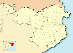
Sant Feliu de Pallerols | |
|---|---|
 | |
| Coordinates: 42°4′36″N 2°30′29″E / 42.07667°N 2.50806°E | |
| Country | |
| Community | |
| Province | |
| Comarca | Garrotxa |
| Government | |
| • Mayor | Joan Casas Carreras (2015)[1] |
| Area | |
• Total | 34.9 km2 (13.5 sq mi) |
| Population (2018)[3] | |
• Total | 1,343 |
| • Density | 38/km2 (100/sq mi) |
| Website | santfeliudepallerols |
Sant Feliu de Pallerols (Catalan pronunciation: [ˈsaɱ fəˈliw ðə pəʎəˈɾɔls]) is a village in the province of Girona and autonomous community of Catalonia, Spain. The municipality covers an area of 34.8 square kilometres (13.4 sq mi) and the population in 2014 was 1,353.[2]
From 1902, Sant Feliu de Pallerols was linked to Girona by the narrow gauge Olot–Girona railway, which was extended to Olot in 1911. The line closed in 1969 and has since been converted into a greenway.[4][5]
The area is notable for its many waterfalls.[6] To visit them you need to book a ticket on the protected Space of the river Brugent. The natural river pools are called: Miami or Boix Pound, Valls pound, and La Mola or la Torra Pound.
- ^ "Ajuntament de Sant Feliu de Pallerols". Generalitat of Catalonia. Retrieved 2015-11-13.
- ^ a b "El municipi en xifres: Sant Feliu de Pallerols". Statistical Institute of Catalonia. Retrieved 2015-11-23.
- ^ Municipal Register of Spain 2018. National Statistics Institute.
- ^ "El tren d'Olot a Girona fa 100 anys" [The train from Olot to Girona is 100 years old] (in Catalan). Sàpiens. 8 November 2011. Archived from the original on 29 November 2022. Retrieved 24 November 2022.
- ^ "Carrilet Olot - Girona Greenway". viasverdes.com. Archived from the original on 24 November 2022. Retrieved 24 November 2022.
- ^ Arnau i Serra, Joan. El Riu Brugent i el seu entorn. Ajuntament de les Planes d'hostoles. 2005. 105 pp. ISBN 84-609-7086-8.


