This article includes a list of general references, but it lacks sufficient corresponding inline citations. (October 2013) |
Santa Ana | |
|---|---|
District of Manila | |
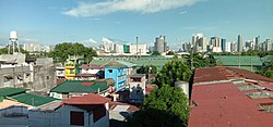
 View of Santa Ana, Manila. Santa Ana Hospital can be seen off-center. | |
 | |
 | |
| Country | Philippines |
| Region | National Capital Region |
| City | Manila |
| Population (2020)[1] | |
• Total | 203,598 |
| Zip codes | 1009 |
| Area codes | 2 |
Santa Ana is a district in the City of Manila, Philippines. It is located on the city's southeast, bordering the cities of Mandaluyong and Makati in the east, the city districts of Paco and Pandacan in the west, and Santa Mesa in the north. It is part of the 6th congressional district of Manila, with thirty-five barangays. Based on the 2020 national census, the Philippine Statistics Authority reports that the district has a population of 203,598.[1]
- ^ a b "2020 Census of Population and Housing Results" (PDF). Philippine Statistics Authority. August 16, 2021. Retrieved April 25, 2022.