| Santa Clara River Rio de Santa Clara[1] | |
|---|---|
 View of Santa Clara River with Rancho Camulos in the foreground, 1888 | |
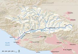
 Map of the Santa Clara River watershed | |
| Native name | Río Santa Clara (Spanish) |
| Location | |
| Country | United States |
| State | California |
| Counties | Los Angeles, Ventura |
| Cities | Oxnard, Ventura, Santa Paula, Fillmore, Santa Clarita |
| Physical characteristics | |
| Source | San Gabriel Mountains |
| • location | Aliso Canyon, Angeles National Forest, Los Angeles County |
| • coordinates | 34°26′01″N 118°21′51″W / 34.43361°N 118.36417°W[2] |
| • elevation | 5,800 ft (1,800 m) |
| Mouth | Pacific Ocean |
• location | Between Ventura and Oxnard, Ventura County |
• coordinates | 34°14′07″N 119°15′49″W / 34.23528°N 119.26361°W[2] |
• elevation | 0 ft (0 m) |
| Length | 83 mi (134 km) |
| Basin size | 1,600 sq mi (4,100 km2) |
| Discharge | |
| • location | Ventura[3] |
| • average | 176 cu ft/s (5.0 m3/s)[3] |
| • minimum | 0 cu ft/s (0 m3/s)[3][note 1] |
| • maximum | 165,000 cu ft/s (4,700 m3/s)[4] |
| Basin features | |
| Tributaries | |
| • right | San Francisquito Creek, Castaic Creek, Piru Creek, Sespe Creek |
The Santa Clara River (Spanish: Río Santa Clara) is an 83 mi (134 km) long[5] river in Ventura and Los Angeles counties in Southern California. It drains parts of four ranges in the Transverse Ranges System north and northwest of Los Angeles, then flows west onto the Oxnard Plain and into the Santa Barbara Channel of the Pacific Ocean.
The watershed has provided habitat for a wide array of native plants and animals and has historically supplied humans with water, fish, and fertile farmland. The northern portion of the watershed was home to the Tataviam people while the southern portion was occupied by the Chumash people. Much of the Santa Clara River Valley is used for agriculture which has limited the use of structural levees to separate the natural floodplain from the river. Although it is one of the least altered rivers in Southern California, some levees exist where the river flows through areas of significant urban development.
- ^ Gudde, Erwin G. (1949). California Place Names: A Geographical Dictionary. Berkeley, CA: University of California Press. p. 315.
- ^ a b U.S. Geological Survey Geographic Names Information System: Santa Clara River
- ^ a b c "USGS Gage #11114000 on the Santa Clara River at Montalvo, CA (Monthly Averages)". National Water Information System. U.S. Geological Survey. 1928–2004. Retrieved September 16, 2010.
- ^ "USGS Gage #11114000 on the Santa Clara River at Montalvo, CA (Peak Streamflow)". National Water Information System. U.S. Geological Survey. 1932–2004. Retrieved September 16, 2010.
- ^ U.S. Geological Survey. National Hydrography Dataset high-resolution flowline data. The National Map, accessed March 16, 2011
Cite error: There are <ref group=note> tags on this page, but the references will not show without a {{reflist|group=note}} template (see the help page).
