Santa Cruz da Graciosa | |
|---|---|
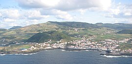
 The municipal seat of Santa Cruz da Graciosa, as seen from off the northeast coast of the island of Graciosa | |
 Location of the municipality of Santa Cruz da Graciosa in the archipelago of the Azores | |
| Coordinates: 39°3′17″N 28°0′51″W / 39.05472°N 28.01417°W | |
| Country | |
| Auton. region | Azores |
| Island | Graciosa |
| Established | Settlement: c.1475 Municipality: c.1832 |
| Parishes | 4 |
| Government | |
| • President | António Reis |
| Area | |
| • Total | 60.66 km2 (23.42 sq mi) |
| Elevation | 140 m (460 ft) |
| Population (2011) | |
| • Total | 4,391 |
| • Density | 72/km2 (190/sq mi) |
| Time zone | UTC−01:00 (AZOT) |
| • Summer (DST) | UTC±00:00 (AZOST) |
| Postal code | 9880-352 |
| Area code | 292 |
| Local holiday | 2nd Monday in August |
| Website | http://cm-graciosa.azoresdigital.pt/ |
Santa Cruz da Graciosa (Portuguese pronunciation: [ˈsɐ̃tɐ ˈkɾuʒ ðɐ ɣɾɐsiˈɔzɐ] ) is a Portuguese municipality on the volcanic island of Graciosa,[1] in the archipelago of the Azores. The population in 2011 was 4,391,[2] in an area of 60.66 km2.[3] It includes four local parishes and one municipal government structure, which administers the entire island.
- ^ "Graciosa Island | Volcanic, Nature Reserve, Wildlife | Britannica". www.britannica.com.
- ^ "Statistics Portugal - Web Portal". www.ine.pt.
- ^ "Eurostat".

