This article includes a list of general references, but it lacks sufficient corresponding inline citations. (March 2016) |
Santa Elena | |
|---|---|
Town | |
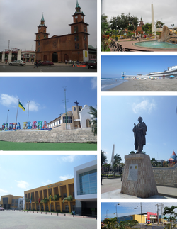
 From top, left to right: Saint Helena Empress Cathedral, Vicente Rocafuerte Central Park, Ballenita beach, El Tablazo viewpoint, monument to Vicente Rocafuerte, City hall of Saint Helena and Sumpa Regional Bus station. | |
| Coordinates: 02°13′36″S 80°51′30″W / 2.22667°S 80.85833°W | |
| Country | |
| Province | Santa Elena |
| Canton | Santa Elena |
| Founded | 1531[citation needed] |
| Area | |
| • Town | 19.48 km2 (7.52 sq mi) |
| Elevation | 26 m (85 ft) |
| Population (2022 census)[1] | |
| • Town | 54,565 |
| • Density | 2,800/km2 (7,300/sq mi) |
| Time zone | UTC-5 hours |
| Climate | BWh |
| Website | www |
Santa Elena (Spanish pronunciation: [ˌsanta eˈlena]) is a town in southwestern Ecuador, and is the capital of both the province and the canton of the same name. Santa Elena, originally called Sumpa, is located on the Ecuadorian peninsula near the city of Guayaquil. It is regarded as the location of the most important and best documented archaeological site in the country, predominantly due to the discovery of the Lovers of Sumpa. [2]
- ^ Citypopulation.de
- ^ Museo Amantes De Sumpa. Ministerio De Turismo.

