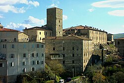
Santa Fiora | |
|---|---|
| Comune di Santa Fiora | |
 | |
| Coordinates: 42°50′N 11°36′E / 42.833°N 11.600°E | |
| Country | Italy |
| Region | Tuscany |
| Province | Grosseto (GR) |
| Frazioni | Bagnolo, Bagnore, Marroneto, Selva |
| Government | |
| • Mayor | Federico Balocchi |
| Area | |
| • Total | 63.45 km2 (24.50 sq mi) |
| Elevation | 687 m (2,254 ft) |
| Population | |
| • Total | 2,542 |
| • Density | 40/km2 (100/sq mi) |
| Demonym | Santafioresi |
| Time zone | UTC+1 (CET) |
| • Summer (DST) | UTC+2 (CEST) |
| Postal code | 58037 |
| Dialing code | 0564 |
| Patron saint | Saints Flora and Lucilla |
| Saint day | July 29 |
| Website | Official website |
Santa Fiora is a comune (municipality) in the province of Grosseto, in the Italian region of Tuscany, located about 110 kilometres (68 miles) southeast of Florence and about 40 km (25 mi) east of Grosseto. Santa Fiora borders the following municipalities: Abbadia San Salvatore, Arcidosso, Castel del Piano, Castell'Azzara, Piancastagnaio, Roccalbegna, and Semproniano. It is one of I Borghi più belli d'Italia ("The most beautiful villages of Italy").[4]
- ^ "Superficie di Comuni Province e Regioni italiane al 9 ottobre 2011". Italian National Institute of Statistics. Retrieved 16 March 2019.
- ^ All demographics and other statistics: Italian statistical institute Istat.
- ^ "Popolazione Residente al 1° Gennaio 2018". Italian National Institute of Statistics. Retrieved 16 March 2019.
- ^ "Toscana" (in Italian). Retrieved 1 August 2023.


