Santa Mesa | |
|---|---|
District of Manila | |
 Aerial view of Santa Mesa | |
 | |
 | |
| Country | Philippines |
| Region | National Capital Region |
| City | Manila |
| Congressional District | 6th District |
| Barangays | 51 |
| Area | |
• Total | 2.6101 km2 (1.0078 sq mi) |
| Population (2020)[1] | |
• Total | 111,292 |
| • Density | 43,000/km2 (110,000/sq mi) |
| Time zone | UTC+08:00 (Philippine Standard Time) |
| Zip codes | 1016 |
| Area codes | 2 |
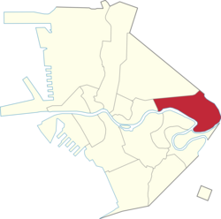
Santa Mesa is a district in Manila, Philippines. It is surrounded by the Pasig River on the southwestern side, and by the San Juan River on its southern and eastern side. Land borders include the districts of San Miguel to the west and Sampaloc to the north; and to the northeast is Quezon City.
Santa Mesa was formerly a part of the Sampaloc district, from which it was partitioned and separated after it had its own parish in 1911. The parish is now known as Old Sta. Mesa (Poblacion), which extends from Victorino Mapa Street (Calle Santa Mesa) to Magsaysay Boulevard (Santa Mesa Boulevard).[2][3]
- ^ "Highlights of the Philippine Population 2015 Census of Population". Philippine Statistics Authority. Retrieved July 11, 2017.
- ^ Alcazaren, Paulo (June 13, 2012). "Sta. Mesa: Manila's northeastern edge". PhilStar.com. Retrieved December 10, 2021.
- ^ "City of Manila, Philippine Islands". Library of Congress. Retrieved 2021-12-10.