 Sentinel-2 satellite image | |
 Santa Rosa Island near the top left | |
| Geography | |
| Location | North Pacific Ocean |
| Coordinates | 33°58′N 120°06′W / 33.967°N 120.100°W |
| Area | 83.12 sq mi (215.3 km2) |
| Area rank | 2nd largest of the Channel Islands |
| Highest elevation | 1,589 ft (484.3 m) |
| Highest point | Soledad Peak |
| Administration | |
United States | |
| State | California |
| County | Santa Barbara |
| National Park | Channel Islands |
| Symbols | |
| Demographics | |
| Population | 2 (2000) |
| Pop. density | 0.024/sq mi (0.0093/km2) |
| Additional information | |
| Time zone | |


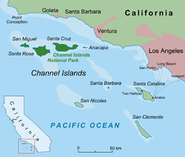
Santa Rosa Island (Spanish: Isla de Santa Rosa; Cruzeño Chumash: Wi'ma)[1] is the second largest of the Channel Islands of California at 53,195 acres (215.27 km2 or 83.118 sq mi). Santa Rosa is located about 26 miles (42 km) off the coast of Santa Barbara, California in Santa Barbara County and is part of Channel Islands National Park.[2]
The Chumash, a Native American people lived on the Channel Islands at the time of European contact.
The remains of a 13,000-year-old Arlington Springs Man, possibly the oldest human remains in the Americas, were discovered on the island in 1959.
Santa Rosa Island is home to the rare Torrey Pine, a species of pine tree that exists only in two locations around the world.
Public passenger access to the eastern portion of Santa Cruz Island is provided by Island Packers ferry service out of the Ventura Harbor.