Santo Amaro | |
|---|---|
| Municipality of Santo Amaro | |
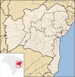
 Location in Bahia | |
| Coordinates: 12°32′49″S 38°42′43″W / 12.54694°S 38.71194°W | |
| Country | |
| Region | Northeast |
| State | |
| Mesoregion | Metropolitana de Salvador |
| Founded | 1557 |
| Government | |
| • Mayor | Alessandra Gomes (PSD) |
| Area | |
| • Total | 492.9 km2 (190.3 sq mi) |
| Population (2020)[1] | |
| • Total | 60,131 |
| • Density | 120/km2 (320/sq mi) |
| Time zone | UTC−3 (BRT) |
| HDI (2010) | 0.646 – medium[2] |
Santo Amaro, also known as Santo Amaro da Purificação (Portuguese pronunciation: [ˈsɐ̃twɐˈmaɾu dɐ puɾifikaˈsɐ̃w]), is a municipality in the state of Bahia in Brazil. The population is 60,131 (2020 est.) in an area of 492.9 square kilometres (190.3 sq mi). It is located in the metropolitan area of Salvador. Santo Amaro is located approximately 73 kilometres (45 mi) from the city of Salvador. Santo Amaro was home to numerous indigenous peoples until the arrival of the Portuguese, who developed the region for sugarcane production. Santo Amaro is now noted for its numerous historic structures. The city is also a center of Candomblé, having more than 60 terreiros, or temples of the religion.[3][4][5]
- ^ IBGE 2020
- ^ "Archived copy" (PDF). United Nations Development Programme (UNDP). Archived from the original (PDF) on July 8, 2014. Retrieved August 1, 2013.
{{cite web}}: CS1 maint: archived copy as title (link) - ^ Instituto Brasileiro de Geografia e Estatística
- ^ "Google Translate". Retrieved 2015-05-15.
- ^ Cite error: The named reference
hpipwas invoked but never defined (see the help page).


