| Satpula | |
|---|---|
 Satpula (Seven arched bridge) | |
| Location | Delhi |
| Coordinates | 28°31′54.23″N 77°13′24.61″E / 28.5317306°N 77.2235028°E |
| Construction began | 1343 AD |
| Dam and spillways | |
| Impounds | Barapulla Nallah |
| Length | 79.5 m (261 ft) |
| Reservoir | |
| Creates | Irrigation |
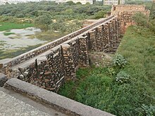
Satpula is a remarkable ancient water harvesting dam or weir located about 800 m (2,625 ft) east of the Khirki Masjid that is integral to the compound wall of the medieval fourth city of the Jahanpanah in Delhi, with its construction credited to the reign of Sultan Muhammad Shah Tughlaq (Muhammad bin Tughluq) (1325–1351) of the Tughlaq Dynasty.[1][2]
The objective of building the weir was for providing water for irrigation and also, as a part of the city wall, to provide defense security to the city against attacking armies.[2][3][4][5]
Satpula is a usage in Hindi languages, which literally means "seven bridges".[2][5]
- ^ "Commonwealth Games-2010, Conservation, Restoration and Upgradation of Public Amenities at Protected Monuments" (PDF). Satpula. Archaeological Survey of India, Delhi Circle. 2006. p. 56.
- ^ a b c "Satpula". Arch Net Digital Library. Retrieved 13 May 2009.
- ^ "Satpula--The Bridge of Seven Openings". Retrieved 13 May 2009.
- ^ "14th Century: Satpula". Retrieved 13 May 2009.
- ^ a b Y.D.Sharma (2001). Delhi and its Neighbourhood. New Delhi: Archaeological Survey of India. pp. 76–77. Archived from the original on 31 August 2005. Retrieved 12 May 2009.
{{cite book}}:|work=ignored (help)