| Sauvie Island Wildlife Area | |
|---|---|
IUCN category V (protected landscape/seascape) | |
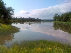
 Sturgeon Lake in the wildlife area | |
| Location | Columbia and Multnomah counties, Oregon |
| Coordinates | 45°43′12″N 122°48′11″W / 45.72°N 122.803°W[1] |
| Area | 12,000 acres (49 km2) |
| Established | 1947 |
| Visitors | About one million (in 2009) |
| Governing body | Oregon Department of Fish and Wildlife |
The Sauvie Island Wildlife Area is a state game management area on Sauvie Island in the U.S. state of Oregon. It contains more than 12,000 acres (4,856 ha)[2] for mixed use including hunting, fishing, canoeing, kayaking, birdwatching and hiking.[3] Established in 1974, it is located in both Multnomah and Columbia counties.[4]
The wildlife area covers the northern half of the island of 24,000 acres (9,700 ha), which lies at the confluence of the Willamette and Columbia rivers. Although the southern half of the island is home to about 500 people as well as farms and related businesses, the northern half, an important stop on the Pacific Flyway, preserves habitat for many kinds of waterfowl. About 300 species of wildlife, including bald eagles, pintails, red-tailed hawks, American kestrels, and many others, frequent the island.[5]
Wetlands and bodies of water, including 21 lakes as well as sloughs, connecting channels, and streams such as the Gilbert River, abound in the wildlife area. Boat ramps provide access to paddlers along the Gilbert, at Oak Island in Sturgeon Lake, and at Steelman Lake, St. Helens, and along the Multnomah Channel. Sandy Columbia River beaches, including one that is clothing-optional, draw large numbers of people to the area's northern edge.[5]
- ^ "Sauvie Island Wildlife Area". Geographic Names Information System. United States Geological Survey, United States Department of the Interior. Retrieved August 9, 2011.
- ^ "Sauvie Island Wildlife Area". Sauvie Island Community Association. Retrieved November 19, 2013.
- ^ "ODFW: Sauvie Island Wildlife Area". Oregon Department of Fish and Wildlife. Retrieved March 31, 2013.
- ^ Cite error: The named reference
planwas invoked but never defined (see the help page). - ^ a b Houck, Michael C.; Cody, M. J., eds. (2000). Wild in the City: A Guide to Portland's Natural Areas. Portland: Oregon Historical Society Press. pp. 323–337. ISBN 0-87595-273-9.
