Saxapahaw, North Carolina | |
|---|---|
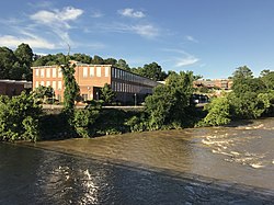
 The renovated Saxapahaw Spinning Mill building along the Haw River in the center of the village | |
 Location of Saxapahaw, North Carolina | |
| Coordinates: 35°56′56″N 79°19′16″W / 35.94889°N 79.32111°W | |
| Country | United States |
| State | North Carolina |
| County | Alamance |
| Founded | 1844 |
| Named for | Sissipahaw Indians[1] |
| Area | |
| • Total | 5.52 sq mi (14.29 km2) |
| • Land | 5.18 sq mi (13.43 km2) |
| • Water | 0.33 sq mi (0.86 km2) |
| Elevation | 512 ft (156 m) |
| Population (2020) | |
| • Total | 1,671 |
| • Density | 322.28/sq mi (124.44/km2) |
| Time zone | UTC-5 (Eastern (EST)) |
| • Summer (DST) | UTC-4 (EDT) |
| ZIP code | 27340 |
| Area code | 336 |
| FIPS code | 37-59580[4] |
| GNIS feature ID | 2402827[3] |
Saxapahaw (/ˈsæksəpəhɔː/ SAKS-uh-puh-haw)[5][6] is a census-designated place (CDP) and unincorporated area in Alamance County, North Carolina, United States. It is part of the Burlington, North Carolina Metropolitan Statistical Area. The population was 1,648 at the 2010 census.[7]
- ^ "North Carolina Gazetteer". Retrieved November 24, 2023.
- ^ "ArcGIS REST Services Directory". United States Census Bureau. Retrieved September 20, 2022.
- ^ a b U.S. Geological Survey Geographic Names Information System: Saxapahaw, North Carolina
- ^ "U.S. Census website". United States Census Bureau. Retrieved 2008-01-31.
- ^ "NC Pronunciation Guide". WRAL. Retrieved August 16, 2023.
- ^ Talk Like a Tarheel Archived 2013-06-22 at the Wayback Machine, from the North Carolina Collection website at the University of North Carolina at Chapel Hill. Retrieved 2023-08-16.
- ^ "Geographic Identifiers: 2010 Demographic Profile Data (G001): Saxapahaw CDP, North Carolina". U.S. Census Bureau, American Factfinder. Archived from the original on February 12, 2020. Retrieved July 2, 2013.