| Scenic Point | |
|---|---|
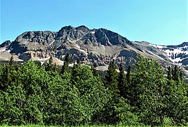
 North aspect, from Two Medicine Road | |
| Highest point | |
| Elevation | 7,522 ft (2,293 m)[1] |
| Prominence | 122 ft (37 m)[1] |
| Parent peak | Mount Henry (8,852 ft)[2] |
| Isolation | 1.92 mi (3.09 km)[2] |
| Coordinates | 48°29′05″N 113°19′20″W / 48.48476945°N 113.32216469°W[3] |
| Geography | |
| Location | Glacier National Park Glacier County, Montana, U.S. |
| Parent range | Lewis Range Rocky Mountains |
| Topo map | USGS Dancing Lady Mountain |
| Climbing | |
| Easiest route | hiking trail |
Scenic Point is a 7,522-foot-elevation (2,293-meter) mountain summit located in the Two Medicine area of Glacier National Park, in Glacier County, Montana, United States.[3] It is situated in the Lewis Range, six miles northwest of East Glacier Park Village, and approximately seven miles east of the Continental Divide, with precipitation runoff from the mountain draining into the Two Medicine River watershed. Topographic relief is significant as the north aspect rises over 2,600 feet (790 meters) above Lower Two Medicine Lake in one mile. Access to the summit is via the Continental Divide National Scenic Trail which traverses the upper slopes of this mountain. The trail to Scenic Point was constructed by the Great Northern Railway, and the summit once hosted a locomotive bell, a Swiss Alps tradition.[4] The mountain's name was officially adopted in 1929 by the United States Board on Geographic Names.[3]
- ^ a b "Scenic Point, Montana". Peakbagger.com. Retrieved 2021-09-29.
- ^ a b "Scenic Point - 7,522' MT". listsofjohn.com. Retrieved 2021-09-29.
- ^ a b c "Scenic Point". Geographic Names Information System. United States Geological Survey, United States Department of the Interior. Retrieved 2021-09-29.
- ^ Aaron Theisen, Day Hiking: Glacier National Park & Western Montana, 2018, Mountaineers Books, ISBN 9781680510492

