This article needs additional citations for verification. (August 2018) |
| Scheldt | |
|---|---|
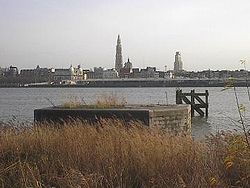
 The Scheldt in Antwerp | |
 Course of the Scheldt | |
| Native name | |
| Location | |
| Countries |
|
| Physical characteristics | |
| Source | |
| • location | France |
| • elevation | 97 m (318 ft) |
| Mouth | |
• location | North Sea |
• coordinates | 51°25′51″N 3°31′44″E / 51.43083°N 3.52889°E |
| Length | 360 km (220 mi) |
| Basin size | 21,863 km2 (8,441 sq mi) |
| Discharge | |
| • average | 104 m3/s (3,700 cu ft/s) |

| |
| Official name | Schorren van de Beneden Schelde |
| Designated | 4 March 1986 |
| Reference no. | 327[1] |
| Official name | Westerschelde & Saeftinghe |
| Designated | 9 April 1995 |
| Reference no. | 748[2] |
| Official name | Vallées de la Scarpe et de l'Escaut |
| Designated | 2 February 2020 |
| Reference no. | 2405[3] |
The Scheldt (/ʃɛlt, skɛlt/ SHELT, SKELT; French: Escaut [ɛsko]; Dutch: Schelde [ˈsxɛldə] ) is a 435-kilometre-long (270 mi)[4] river that flows through northern France, western Belgium, and the southwestern part of the Netherlands, with its mouth at the North Sea. Its name is derived from an adjective corresponding to Old English sċeald ("shallow"), Modern English shoal, Low German schol, West Frisian skol, and obsolete Swedish skäll ("thin").[citation needed]
- ^ "Schorren van de Beneden Schelde". Ramsar Sites Information Service. Retrieved 25 April 2018.
- ^ "Westerschelde & Saeftinghe". Ramsar Sites Information Service. Retrieved 25 April 2018.
- ^ "Vallées de la Scarpe et de l'Escaut". Ramsar Sites Information Service. Retrieved 3 February 2020.
- ^ "VNSC Communicatie : vraagbaak voor alles op, rond en in de Schelde" (in Dutch). Retrieved 2014-06-03.


