| Schilthorn | |
|---|---|
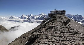
 Schilthorn's summit, with the Piz Gloria restaurant; in the distance are the Eiger, Mönch, and Jungfrau. | |
| Highest point | |
| Elevation | 2,970 m (9,740 ft) |
| Prominence | 358 m (1,175 ft)[1] |
| Parent peak | Finsteraarhorn |
| Isolation | 3.6 km (2.2 mi)[2] |
| Listing | Alpine mountains 2500-2999 m |
| Coordinates | 46°33′26″N 7°50′07″E / 46.55722°N 7.83528°E |
| Geography | |
| Location | Bernese Oberland, Switzerland |
| Parent range | Bernese Alps |

The Schilthorn (2,970 metres (9,744 ft)) is a summit in Europe, in the Bernese Alps of Switzerland. It overlooks the valley of Lauterbrunnen in the Bernese Oberland, and is the highest mountain in the range lying north of the Sefinenfurgge Pass. The Schilthorn lies above the village of Mürren, from where a cable car leads to its summit.[3]
Administratively, the summit is within the municipality of Lauterbrunnen, although the western slopes are within the municipality of Reichenbach im Kandertal. Both municipalities are in the canton of Bern.[3]
The summit has a panoramic view which spans from the Titlis, Jungfrau, Mönch, Eiger, over the Bernese Alps and the Jura mountains up to the Vosges Mountains and the Black Forest. Mont Blanc is also just visible.
- ^ Retrieved from the Swisstopo topographic maps. The key col is the Sefinenfurgge (2,612 m).
- ^ Retrieved from Google Earth. The nearest point of higher elevation is north of the Bütlasse.
- ^ a b map.geo.admin.ch (Map). Swiss Confederation. Retrieved 2014-11-03.

