| Schoharie Creek | |
|---|---|
 Schoharie Creek flowing into the Mohawk River, from Tribes Hill Park in Amsterdam, New York. | |
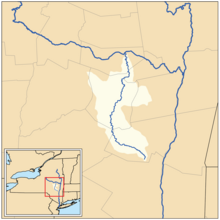
 Map of the Schoharie Creek drainage basin | |
| Location | |
| Country | United States |
| State | New York |
| Physical characteristics | |
| Source | Indian Head Mountain |
| Mouth | Mohawk River |
• location | Fort Hunter |
• coordinates | 42°56′28″N 74°17′32″W / 42.94111°N 74.29222°W |
• elevation | 274 ft (84 m) |
| Length | 93 mi (150 km) |
| Basin size | 928 sq mi (2,400 km2)[1] |
| Discharge | |
| • location | Burtonsville |
| • minimum | 2.4 cu ft/s (0.068 m3/s) |
| • maximum | 128,000 cu ft/s (3,600 m3/s) |
| Basin features | |
| Progression | Schoharie Creek → Mohawk River → Hudson River → Upper New York Bay |
| Tributaries | |
| • left | West Kill, Panther Creek, Cobleskill Creek |
| • right | East Kill, Batavia Kill, Little Schoharie Creek, Fox Creek |


Schoharie Creek is a river in New York that flows north 93 miles (150 km)[2] from the foot of Indian Head Mountain in the Catskills through the Schoharie Valley to the Mohawk River. It is twice impounded north of Prattsville to create New York City's Schoharie Reservoir and the Blenheim-Gilboa Power Project.
The Erie Canal crossed over the creek by an aqueduct at Schoharie Crossing State Historic Site.
Two notable bridge collapses have occurred on Schoharie Creek. In 1987, two spans of the New York State Thruway collapsed. On August 28, 2011, the covered Old Blenheim Bridge collapsed due to flooding from Hurricane Irene.
- ^ "USGS 0135399605 SCHOHARIE CREEK AT MOUTH NEAR FORT HUNTER NY". National Water Information System. United States Geological Survey. 2019. Retrieved May 31, 2019.
- ^ "The National Map". U.S. Geological Survey. Retrieved Feb 11, 2011.