Schwarzenberg | |
|---|---|
 | |
Location of Schwarzenberg within Erzgebirgskreis district  | |
| Coordinates: 50°32′43″N 12°46′45″E / 50.54528°N 12.77917°E | |
| Country | Germany |
| State | Saxony |
| District | Erzgebirgskreis |
| Subdivisions | 6 |
| Government | |
| • Mayor (2020–27) | Ruben Gehart[1] (CDU) |
| Area | |
| • Total | 46.25 km2 (17.86 sq mi) |
| Elevation | 468 m (1,535 ft) |
| Population (2022-12-31)[2] | |
| • Total | 15,936 |
| • Density | 340/km2 (890/sq mi) |
| Time zone | UTC+01:00 (CET) |
| • Summer (DST) | UTC+02:00 (CEST) |
| Postal codes | 08340 |
| Dialling codes | 03774 |
| Vehicle registration | ERZ, ANA, ASZ, AU, MAB, MEK, STL, SZB, ZP |
| Website | www.schwarzenberg.de |
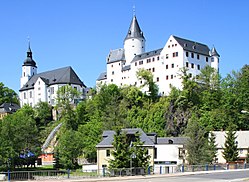
Schwarzenberg is a town in the district of Erzgebirgskreis in Saxony’s Ore Mountains, near the German–Czech border. The town lies roughly 15 km southeast of Aue, and 35 km southwest of Chemnitz.
Founded in the 12th century to protect a trade road, the small mountain town became the centre of a territory known as Herrschaft Schwarzenberg and later Amt Schwarzenberg. During the division of Germany, Schwarzenberg was part of East Germany and became the greatest producer of washing machines in Eastern Europe. Schwarzenberg became more widely known in 1987, when Stefan Heym coined the term Free Republic of Schwarzenberg for a small gap between the Soviet and American occupation zones in May/June 1945.
- ^ Wahlergebnisse 2020, Freistaat Sachsen, accessed 10 July 2021.
- ^ "Einwohnerzahlen nach Gemeinden als Excel-Arbeitsmappe" (XLS) (in German). Statistisches Landesamt des Freistaates Sachsen. 2024.


