| Scioto Mile | |
|---|---|
 | |
 Interactive map of the park network | |
| Coordinates | 39°57′35″N 83°00′14″W / 39.9598°N 83.0040°W |
| Administered by | Columbus Recreation and Parks Department |
| Public transit access | |
| Website | Official website |
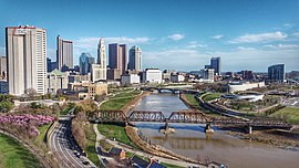
The Scioto Mile is a collection of parks and trails along both banks of the Scioto River in Columbus, Ohio, connecting parts of the Scioto Greenway Trail with downtown Columbus and Franklinton. The nine parks cover 145 acres (59 ha).[1]
- ^ "FAQ | Downtown Columbus Park Rules & Information". Scioto Mile. Retrieved 2020-04-07.