Scotia | |
|---|---|
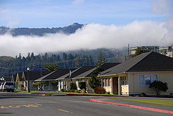
 Main Street in Scotia | |
| Coordinates: 40°28′56″N 124°06′03″W / 40.48222°N 124.10083°W | |
| Country | |
| State | |
| County | Humboldt |
| Area | |
| • Total | 0.842 sq mi (2.179 km2) |
| • Land | 0.746 sq mi (1.932 km2) |
| • Water | 0.096 sq mi (0.247 km2) 11.3% |
| Elevation | 194[2] ft (59 m) |
| Population | |
| • Total | 681 |
| • Density | 810/sq mi (310/km2) |
| Time zone | UTC-8 (Pacific) |
| • Summer (DST) | UTC-7 (PDT) |
| ZIP code | 95565[4] |
| Area code | 707 |
| FIPS code | 06-70518 |
| GNIS feature IDs | 232715, 2611446 |
| Website | www |
| U.S. Geological Survey Geographic Names Information System: Scotia, California; U.S. Geological Survey Geographic Names Information System: Scotia, California | |
Scotia, formerly known as Forestville until 1888, is a census-designated place in Humboldt County, California.[5][6][2] It is located on the Eel River along U.S. Route 101, 8.5 miles (13.7 km) southeast of Fortuna and 244 miles (393 km) north of San Francisco.[5] Scotia has a population of 850 (2010 census).
Scotia was a company town founded by the Pacific Lumber Company (PALCO) to house workers for the lumber industry. The town was entirely owned by PALCO until 2008, following the corporation's declaration of bankruptcy. While it is home to hundreds of past or present lumber mill employees and their dependents, a process is underway to divide the homes into lots for sale.
- ^ "2010 Census U.S. Gazetteer Files – Places – California". United States Census Bureau.
- ^ a b c U.S. Geological Survey Geographic Names Information System: Scotia, California
- ^ "Explore Census Data". data.census.gov. Retrieved May 6, 2023.
- ^ "ZIP Code™ Lookup - USPS". zip4.usps.com.
- ^ a b Durham, David L. (1998). California's Geographic Names: A Gazetteer of Historic and Modern Names of the State. Clovis, Calif.: Word Dancer Press. p. 139. ISBN 1-884995-14-4.
- ^ U.S. Geological Survey Geographic Names Information System: Scotia, California

