This article needs additional citations for verification. (April 2011) |
Scottburgh | |
|---|---|
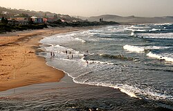
 View of Scottburgh Beach | |
| Coordinates: 30°17′S 30°45′E / 30.283°S 30.750°E | |
| Country | |
| Province | |
| District | Ugu |
| Municipality | uMdoni |
| Established | 1860[1] |
| Area | |
• Total | 23.80 km2 (9.19 sq mi) |
| Elevation | 19 m (62 ft) |
| Population (2011)[2] | |
• Total | 11,403 |
| • Density | 480/km2 (1,200/sq mi) |
| Racial makeup (2011) | |
| • Black African | 27.7% |
| • Coloured | 3.0% |
| • Indian/Asian | 22.0% |
| • White | 46.8% |
| • Other | 0.6% |
| First languages (2011) | |
| • English | 68.0% |
| • Zulu | 16.0% |
| • Afrikaans | 11.2% |
| • Xhosa | 2.1% |
| • Other | 2.7% |
| Time zone | UTC+2 (SAST) |
| Postal code (street) | 4180 |
| PO box | 4180 |
| Area code | 039 |
Scottburgh (/ˈskɒtbərə/) is a coastal resort town located along the south coast of KwaZulu-Natal, South Africa. It situated south of the mouth of the Mpambanyoni River (confuser of birds).[3]: 332
Prior to 1 December 2023, vehicle registration plates in Scottburgh started with NX - N for Natal, X for Alexandra as the town once formed part of the Alexandra County in the 1800s along with Umzinto, Umkomaas, Park Rynie and Sezela-Pennington.[4][5] The reason why it was not registered as NA instead was because the town of Harding, 140 kilometres south-west, already bore the vehicle registration “NA”.
- ^ Robson, Linda Gillian (2011). "Annexure A" (PDF). The Royal Engineers and settlement planning in the Cape Colony 1806–1872: Approach, methodology and impact (PhD thesis). University of Pretoria. pp. xlv–lii. hdl:2263/26503.
- ^ a b c d "Main Place Scottburgh". Census 2011.
- ^ Vic Mayhew, ed. (1980). Illustrated guide to Southern Africa. Cape Town: Reader's Digest Association South Africa in association with T.V. Bulpin. ISBN 978-0-620-04650-3.
- ^ https://www.natalia.org.za/Files/44/Article%20Du%20Bois%20pp%2033%20%20to%2047.pdf [bare URL PDF]
- ^ https://natalia.org.za/Files/45/Natalia%20No%2045%20Article%20Umkomaas.pdf [bare URL PDF]


