| Sedgeford | |
|---|---|
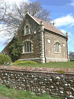
 Magazine, the old gunpowder store at Sedgeford | |
Location within Norfolk | |
| Area | 6.6 sq mi (17 km2) |
| Population | 613 (2011) |
| • Density | 93/sq mi (36/km2) |
| OS grid reference | TF712366 |
| • London | 100 mi (160 km) |
| Civil parish |
|
| District | |
| Shire county | |
| Region | |
| Country | England |
| Sovereign state | United Kingdom |
| Post town | HUNSTANTON |
| Postcode district | PE36 |
| Police | Norfolk |
| Fire | Norfolk |
| Ambulance | East of England |
Sedgeford is a village and civil parish in the English county of Norfolk, about 5 miles south of the North Sea and 3 miles (4.8 km) east of the Wash. It is 36 miles northwest of Norwich.
Its area of 6.6 square miles (17 km2) had a population, including Fring, of 613 at the 2011 Census. It was estimated to have a population of 601 in 2019.[1] It belongs to the local governance of King's Lynn and West Norfolk district. It lies in a farming valley with main crops of barley, wheat and sugar beet, in a belt of chalk with the small Docking River running through.
