Seine-Maritime | |
|---|---|
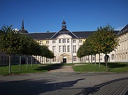
 Prefecture building of the Seine-Maritime department, in Rouen | |
 Location of Seine-Maritime in France | |
| Coordinates: 49°40′N 0°50′E / 49.667°N 0.833°E | |
| Country | France |
| Region | Normandy |
| Prefecture | Rouen |
| Subprefectures | Dieppe Le Havre |
| Government | |
| • President of the Departmental Council | Bertrand Bellanger[1] |
| Area | |
| • Total | 6,278 km2 (2,424 sq mi) |
| Population (2021)[2] | |
| • Total | 1,255,918 |
| • Rank | 16th |
| • Density | 200/km2 (520/sq mi) |
| Time zone | UTC+1 (CET) |
| • Summer (DST) | UTC+2 (CEST) |
| ISO 3166 code | FR-76 |
| Department number | 76 |
| Arrondissements | 3 |
| Cantons | 35 |
| Communes | 708 |
| ^1 French Land Register data, which exclude estuaries, and lakes, ponds, and glaciers larger than 1 km2 | |
Seine-Maritime (French pronunciation: [sɛn maʁitim] ) is a department of France in the Normandy region of northern France. It is situated on the northern coast of France, at the mouth of the Seine, and includes the cities of Rouen and Le Havre. Until 1955 it was named Seine-Inférieure. It had a population of 1,255,633 in 2019.[3]
- ^ "Répertoire national des élus: les conseillers départementaux". data.gouv.fr, Plateforme ouverte des données publiques françaises (in French). 4 May 2022.
- ^ "Téléchargement du fichier d'ensemble des populations légales en 2021" (in French). The National Institute of Statistics and Economic Studies. 28 December 2023.
- ^ Populations légales 2019: 76 Seine-Maritime, INSEE

