Seka
เซกา | |
|---|---|
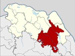
 District location in Bueng Kan province | |
| Coordinates: 17°55′42″N 103°57′12″E / 17.92833°N 103.95333°E | |
| Country | Thailand |
| Province | Bueng Kan |
| Seat | Seka |
| Subdistricts | 9 |
| Mubans | 131 |
| District established | 1958 |
| Area | |
• Total | 978.428 km2 (377.773 sq mi) |
| Population (2015) | |
• Total | 86,087 |
| • Density | 82.3/km2 (213/sq mi) |
| Time zone | UTC+7 (ICT) |
| Postal code | 38150 |
| Geocode | 3804 |
Seka (Thai: เซกา, pronounced [sēːkāː]) is a district (amphoe) in the eastern part of Bueng Kan province, northeastern Thailand.