This article needs additional citations for verification. (July 2015) |
Selwyn District | |
|---|---|
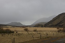
 Photo taken from the TranzAlpine train | |
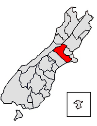
 Location of the Selwyn District within the South Island | |
| Coordinates: 43°34′34″S 172°03′36″E / 43.576°S 172.06°E | |
| Country | New Zealand |
| Region | Canterbury |
| Wards |
|
| Formed | 1989 |
| Seat | Rolleston |
| Government | |
| • Mayor | Sam Broughton |
| • Deputy Mayor | Malcolm Lyall |
| • Territorial authority | Selwyn District Council |
| Area | |
| • Total | 6,381.15 km2 (2,463.78 sq mi) |
| Population (June 2023)[2] | |
| • Total | 81,300 |
| • Density | 13/km2 (33/sq mi) |
| Time zone | UTC+12 (NZST) |
| • Summer (DST) | UTC+13 (NZDT) |
| Postcode(s) | |
| Website | www |
Selwyn District is a predominantly rural district in central Canterbury, on the east coast of New Zealand's South Island. It is named after the Selwyn River / Waikirikiri, which is in turn named after Bishop George Selwyn, the first Anglican bishop of New Zealand who, in 1843 and 1844, travelled the length of the country by horse, foot, boat and canoe, leaving in his wake a sprinkling of locations that now bear his name.
- ^ Cite error: The named reference
Areawas invoked but never defined (see the help page). - ^ "Subnational population estimates (RC, SA2), by age and sex, at 30 June 1996-2023 (2023 boundaries)". Statistics New Zealand. Retrieved 25 October 2023. (regional councils); "Subnational population estimates (TA, SA2), by age and sex, at 30 June 1996-2023 (2023 boundaries)". Statistics New Zealand. Retrieved 25 October 2023. (territorial authorities); "Subnational population estimates (urban rural), by age and sex, at 30 June 1996-2023 (2023 boundaries)". Statistics New Zealand. Retrieved 25 October 2023. (urban areas)