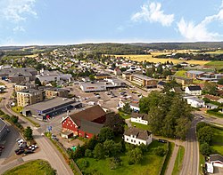
Sem
Semsbyen | |
|---|---|
Village | |
 View of the village | |
| Coordinates: 59°16′56″N 10°19′48″E / 59.2823°N 10.33004°E | |
| Country | Norway |
| Region | Eastern Norway |
| County | Vestfold |
| District | Jarlsberg |
| Municipality | Tønsberg Municipality |
| Area | |
• Total | 2.02 km2 (0.78 sq mi) |
| Elevation | 18 m (59 ft) |
| Population (2023)[1] | |
• Total | 2,733 |
| • Density | 1,350/km2 (3,500/sq mi) |
| Time zone | UTC+01:00 (CET) |
| • Summer (DST) | UTC+02:00 (CEST) |
| Post Code | 3170 Sem |
Sem or Semsbyen is a village in Tønsberg Municipality in Vestfold county, Norway. The village is located about 5 kilometres (3.1 mi) to the west of the city of Tønsberg. The village of Vear lies about 3 kilometres (1.9 mi) to the southeast of Sem, along the shore of the Tønsbergfjorden. The historic Sem Church is located just northeast of the village.[3]
The village lies along the border with Sandefjord Municipality to the southwest (in fact, a small portion of the urban area of Sem crosses over the border and has about 50 residents in the neighboring municipality). The 2.02-square-kilometre (500-acre) village has a population (2023) of 2,733 and a population density of 1,350 inhabitants per square kilometre (3,500/sq mi).[1]
The village of Sem was the administrative centre of the old Sem Municipality which existed from 1838 until 1988 when it became part of Tønsberg Municipality.[3]
- ^ a b c Statistisk sentralbyrå (1 January 2023). "Urban settlements. Population and area, by municipality".
- ^ "Sem, Tønsberg". yr.no. Retrieved 3 February 2024.
- ^ a b Thorsnæs, Geir, ed. (20 December 2023). "Sem (tettsted i Tønsberg)". Store norske leksikon (in Norwegian). Kunnskapsforlaget. Retrieved 3 February 2024.

