| Seminary Ridge | |
|---|---|
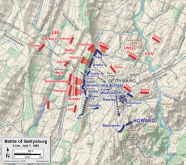
 July 1, 1863, at 4:00 p.m.: Union troops (blue) occupied Seminary Ridge. | |
| Highest point | |
| Peak | driveway entrance, SW Confederate Av |
| Elevation | 581.60 ft (177.27 m)[1] |
| Naming | |
| Etymology | Lutheran Theological Seminary |
| Geography | |
 | |
| Location | Triple watershed point: Pitzer's Run (west) & both Stevens Creek/Plum Run (east)[citation needed] |
| Country | United States |
| State | Pennsylvania |
| Range coordinates | 39°49′25″N 77°14′43″W / 39.82361°N 77.24528°W |
| Biome | Northern Piedmont ecoregion |
| Geology | |
| Rock types |
|
Seminary Ridge is a dendritic ridge that served as an area of military engagements during the Battle of Gettysburg, the bloodiest battle of the American Civil War, which was fought between July 1 and July 3, 1863 in and around Gettysburg, Pennsylvania. Seminary Ridge also served as a military installation during World War II.
- ^ "Y_Value=39.8211&X_Value=-77.2461 ... 581.60". USGS Elevation Web Service Query. United States Geological Survey. Archived from the original on 2011-07-22. Retrieved 2010-02-02.
{{cite web}}: External link in|work= - ^ "Gettysburg National Military Park and Eisenhower National Historic Site: Geologic Resources Inventory Report" (PDF). Denver, Colorado: National Park Service: Natural Resource Program Center. 2009. Archived from the original (PDF) on 2017-05-11. Retrieved 2010-02-02.