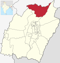
Senapati district | |
|---|---|
 Location in Manipur | |
| Country | |
| State | Manipur |
| Headquarters | Senapati (Tahamzam) |
| Tehsils | 1. Purul, 2. Paomata, 3. Mao-Maram,[1] |
| Government | |
| • Vidhan Sabha constituencies | 6: Saikul, Karong, Mao, Tadubi, Kangpokpi and Saitu |
| Area | |
• Total | 1,573 km2 (607 sq mi) |
| • Rank | 8 |
| Population (2011)[2] | |
• Total | 285,404 |
| • Density | 180/km2 (470/sq mi) |
| Demographics | |
| • Literacy | 74.13%[2] |
| • Sex ratio | 923[2] |
| Language(s) | |
| • Official | English |
| • Regional | Mao |
| Time zone | UTC+05:30 (IST) |
| Vehicle registration | MN03[3] |
| Website | senapati |
Senapati district (Meitei pronunciation:/se.na.pə.ti/), is one of the 16 districts of the Indian state of Manipur. The present Senapati district was formed in December 2016, after spawning off the Sadar Hills region in the south into a separate Kangpokpi district.[4] The district headquarter is located in the town of Senapati, also known as Tahamzam.
- ^ "Official Website of Senapati District Manipur-District Profile". Archived from the original on 15 July 2013.
- ^ a b c Cite error: The named reference
districtcensuswas invoked but never defined (see the help page). - ^ "娱乐是一种态度".
- ^ "7 new districts formed in Manipur amid opposition by Nagas". India Today. 9 December 2016. Retrieved 30 June 2017.