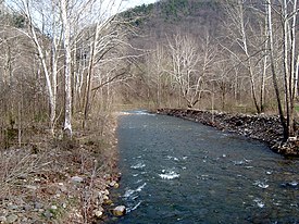
| Seneca Creek | |
|---|---|
 Seneca Creek just upstream of its mouth | |
 | |
| Location | |
| Country | United States |
| State | West Virginia |
| Counties | Pendleton |
| Physical characteristics | |
| Source | Slab Camp Run |
| • location | Allegheny Mountain, Pendleton County, WV |
| • coordinates | 38°43′29″N 79°33′23″W / 38.72472°N 79.55639°W |
| • elevation | 3,912 ft (1,192 m)[1] |
| 2nd source | Trussel Run |
| • location | Spruce Mountain, Pocahontas County, WV |
| • coordinates | 38°42′47″N 79°32′31″W / 38.71306°N 79.54194°W |
| • elevation | 3,944 ft (1,202 m)[2] |
| Source confluence | |
| • location | Pendleton County, WV |
| • coordinates | 38°43′04″N 79°32′46″W / 38.71778°N 79.54611°W |
| • elevation | 3,747 ft (1,142 m)[3] |
| Mouth | North Fork South Branch Potomac River[4] |
• location | Seneca Rocks, WV |
• coordinates | 38°09′42″N 81°11′47″W / 38.16167°N 81.19639°W |
• elevation | 1,532 ft (467 m) |
Seneca Creek is a 19.6-mile-long (31.5 km)[5] tributary of the North Fork of the South Branch of the Potomac River located entirely within Pendleton County, West Virginia, USA.
Seneca Creek lies within the Appalachian Mountains, in the Spruce Knob–Seneca Rocks National Recreation Area of the Monongahela National Forest. It is formed by two spring-fed streams, Slab Camp Run and Trussel Run, on the western flanks of Spruce Mountain to the north of Spruce Knob. It empties into the North Fork of the South Branch at the community of Seneca Rocks near the base of the Seneca Rocks sandstone cliff formation.
- ^ "Slab Camp Run Source". Elevation Query. U.S. Geological Survey. Retrieved 2008-09-13.
- ^ "Trussel Run Source". Elevation Query. U.S. Geological Survey. Retrieved 2008-09-13.
- ^ "Trussel Run". Geographic Names Information System. United States Geological Survey, United States Department of the Interior. 1980-06-27. Retrieved 2008-09-13.
- ^ "Seneca Creek". Geographic Names Information System. United States Geological Survey, United States Department of the Interior. 1980-06-27. Retrieved 2008-09-13.
- ^ U.S. Geological Survey. National Hydrography Dataset high-resolution flowline data. The National Map, accessed August 15, 2011