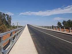
Senegambia Bridge | |
|---|---|
 | |
| Coordinates | 13°30′59″N 15°34′21″W / 13.51639°N 15.57250°W |
| Carries | Trans-Gambia Highway and Highway N4 |
| Crosses | Gambia River |
| Locale | Bamba Tenda, Gambia and Yelitenda, Gambia |
| Other name(s) | Trans-Gambia Bridge |
| Maintained by | National Roads Authority[1] |
| Characteristics | |
| Total length | 1.9 kilometres (1.2 mi) |
| Width | 12 metres (39 ft) |
| Longest span | 100 metres (110 yd) |
| History | |
| Designer | BCEOM and SCET Tunisie |
| Constructed by | Isolux Corsán and the Arezki Group |
| Construction cost | US$ 93 million |
| Opened | January 21, 2019 |
| Statistics | |
| Toll | US$ 5 for cars |
| Location | |
 | |
The Senegambia bridge, also known as the Trans-Gambia Bridge, is a bridge in The Gambia that carries the Trans-Gambia Highway connecting northern and southern Gambia. It also provides access to the isolated Casamance province from the rest of Senegal. A bridge had been proposed for this location in 1956 but political considerations delayed construction which finally began in 2015. Construction was funded largely by a loan of US$ 65 million from the African Development Bank, with remaining funding coming from the Gambian government. Construction works were carried out by a joint venture of Spanish company Isolux Corsán and the Senegalese Arezki Group.
The bridge, made from reinforced concrete, opened to light vehicles on 21 January 2019. At 1.9 kilometres (1.2 mi) in length it is one of West Africa's longest bridges and includes a 100-metre-wide (110 yd) central span to facilitate continued use of the river by boats. The Senegambia bridge forms part of the Trans-Gambia Highway and the Trans–West African Coastal Highway.
- ^ "Trans-Gambia Corridor Project". National Roads Authority. Retrieved 2 February 2019.