This article possibly contains original research. (March 2019) |
Shenkottai
Shencottah | |
|---|---|
Town | |
| Shenkottai | |
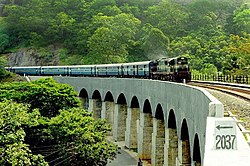
 13 kannara bridge in Kerala near Sengottai | |
| Nickname: Red Fort | |
| Coordinates: 8°58′24″N 77°14′47″E / 8.973333°N 77.246389°E | |
| Country | |
| State | Tamil Nadu |
| District | Tenkasi |
| Revenue Division | Tenkasi |
| Taluk | Sengottai |
| Named for | Red fort |
| Government | |
| • Type | Second Grade Municipality |
| • Body | Shencottah Municipality |
| Area | |
• Total | 2.68 km2 (1.03 sq mi) |
| Elevation | 181 m (594 ft) |
| Population (2011) | |
• Total | 26,823 |
| • Density | 10,000/km2 (26,000/sq mi) |
| Languages | |
| • Official | Tamil |
| • Other Regional languages | Malayalam |
| Time zone | UTC+5:30 (IST) |
| PIN | 627809 |
| Telephone code | 04633 |
| Vehicle registration | TN-76 |
| Sex ratio | ♂/♀ 1035 |
| Website | www.municipality.tn.go.in/sengottai |
Sengottai (also known as Shencottah, Chenkotta or Shenkottai) is a town in the Tenkasi district, of Tamil Nadu, India. It is the gateway to southern Tamil Nadu and Kerala. Spread over an area of 2.68 km2 with a population of over 26,823, the economy of the town and Sengottai Taluk revolves around the cultivation of rice,coconut,Mango,clove and pepper. Sengottai is well known in Tamil Nadu as a major market of Dosa kal (commonly known as Dosa tawa). This town has lot of Black smith shops. [1]
- ^ "Sengottai Municipality". Municipality. Retrieved 8 May 2012.
