Senja Municipality
Senja kommune | |
|---|---|
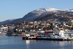
 View of Finnsnes in Senja | |
 Troms within Norway | |
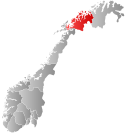
 Senja within Troms | |
| Coordinates: 69°04′50″N 16°48′11″E / 69.0806°N 16.8031°E | |
| Country | Norway |
| County | Troms |
| District | Hålogaland |
| Established | 1 Jan 2020 |
| • Preceded by | Berg, Tranøy, Torsken, and Lenvik |
| Administrative centre | Finnsnes |
| Government | |
| • Mayor (2023) | Geir-Inge Sivertsen (H) |
| Area | |
• Total | 1,946.09 km2 (751.39 sq mi) |
| • Land | 1,860.90 km2 (718.50 sq mi) |
| • Water | 85.19 km2 (32.89 sq mi) 4.4% |
| • Rank | #40 in Norway |
| Highest elevation | 1,202.4 m (3,944.9 ft) |
| Population (2024) | |
• Total | 14,894 |
| • Rank | #83 in Norway |
| • Density | 7.7/km2 (20/sq mi) |
| • Change (10 years) | |
| Demonyms | Senjaværing Senjeværing[2] |
| Official language | |
| • Norwegian form | Neutral |
| Time zone | UTC+01:00 (CET) |
| • Summer (DST) | UTC+02:00 (CEST) |
| ISO 3166 code | NO-5530[4] |
| Website | Official website |
Senja is a municipality in Troms county, Norway. It was established on 1 January 2020 when the municipalities of Berg, Lenvik, Torsken, and Tranøy were merged into one municipality. It is located in the traditional district of Hålogaland. The administrative centre of the municipality is the town of Finnsnes. Some of the notable villages in Senja include Å, Aglapsvik, Bjorelvnes, Botnhamn, Finnsæter, Fjordgård, Flakstadvåg, Gibostad, Gryllefjord, Husøy, Langnes, Laukhella, Lysnes, Medby, Mefjordvær, Rossfjordstraumen, Sandbakken, Senjahopen, Silsand, Skaland, Skrollsvika, Stonglandseidet, Torsken, and Vangsvik.
The municipality includes all of the island of Senja, the smaller surrounding islands, and part of the mainland between the Gisundet strait and the Malangen fjord.[5] The 1,946-square-kilometre (751 sq mi) municipality is the 40th largest by area out of the 357 municipalities in Norway. Senja is the 83rd most populous municipality in Norway with a population of 14,894. The municipality's population density is 87.7 inhabitants per square kilometre (227/sq mi) and its population has increased by 0.2% over the previous 10-year period.[6][7]
- ^ "Høgaste fjelltopp i kvar kommune" (in Norwegian). Kartverket. 16 January 2024.
- ^ "Navn på steder og personer: Innbyggjarnamn" (in Norwegian). Språkrådet.
- ^ "Forskrift om målvedtak i kommunar og fylkeskommunar" (in Norwegian). Lovdata.no.
- ^ Bolstad, Erik; Thorsnæs, Geir, eds. (26 January 2023). "Kommunenummer". Store norske leksikon (in Norwegian). Kunnskapsforlaget.
- ^ Thorsnæs, Geir, ed. (9 May 2018). "Senja". Store norske leksikon (in Norwegian). Kunnskapsforlaget. Retrieved 25 August 2018.
- ^ Statistisk sentralbyrå. "Table: 06913: Population 1 January and population changes during the calendar year (M)" (in Norwegian).
- ^ Statistisk sentralbyrå. "09280: Area of land and fresh water (km²) (M)" (in Norwegian).
