Serei Saophoan
សិរីសោភ័ណ Sisophon | |
|---|---|
| Serei Saophoan Municipality ក្រុងសិរីសោភ័ណ | |
 Small lake in Serei Saophoan Municipality | |
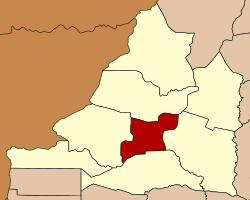
 Map showing the location of the district within Banteay Meanchey Province. | |
| Coordinates: 13°35′N 102°59′E / 13.583°N 102.983°E | |
| Country | |
| Province | Banteay Meanchey |
| Communes | 7 |
| Villages | 42 |
| Population (2008) | |
| • Total | 90,279 |
| Time zone | UTC+07:00 (ICT) |
| Geocode | 0106 |
Serei Saophoan (Khmer: សិរីសោភ័ណ [serəj saopʰɔən]; lit. 'The Glorious and Auspicious') is a municipality (krong) in the centre of Banteay Meanchey province, in north-western Cambodia. Serei Saophoan is the urban district of Banteay Meanchey province and the district capital is also the provincial capital Sisophon town. The town is located 359 kilometres north of Phnom Penh and 48 kilometres from the border with Thailand at Poipet. Serei Saophoan municipality is the central municipality of Banteay Meanchey and is surrounded by other Banteay Meanchey districts. Cambodia's main railway line from Phnom Penh to Poipet enters the municipality from the south and exits to the west.[1]
The municipality is easily accessed by road from Phnom Penh (359 km) Battambang (68 km) and Siem Reap (city) (102 km). Serei Saophoan municipality is the smallest municipality in Banteay Meanchey province by land area. However, it has one of the largest municipality populations in the province due to its central location and access to transport infrastructure. National Highway 5 which begins in Phnom Penh and ends at Poipet and the National railway both bisect the municipality in parallel. National Highway 6 which begins in Phnom Penh also has its terminus at Sisophon town in Serei Saophoan. National road 56 begins at Sisophon town in the centre of the municipality and runs north east to Samraong in Oddar Meanchey province.[2]
