This article needs additional citations for verification. (November 2010) |
Shadyside | |
|---|---|
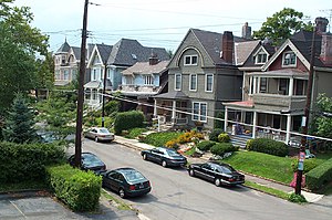
 Street in Shadyside, 2001 | |
 | |
| Coordinates: 40°27′00″N 79°56′06″W / 40.450°N 79.935°W | |
| Country | United States |
| State | Pennsylvania |
| County | Allegheny County |
| City | Pittsburgh |
| Area | |
• Total | 0.921 sq mi (2.39 km2) |
| Population (2010)[1] | |
• Total | 13,915 |
| • Density | 15,000/sq mi (5,800/km2) |
Shadyside is a neighborhood in the East End of Pittsburgh, Pennsylvania, United States. It has three zip codes (15206, 15213, and 15232) and representation on Pittsburgh City Council by the council member for District 8 (East Central Neighborhoods). Shadyside is drawn from the name of a 19th-century Pennsylvania Railroad station in the area, which was named for its shady lanes.
Notable neighborhood institutions include UPMC Shadyside hospital, a member of the University of Pittsburgh Medical Center; Chatham University, which is located just across the southern edge of the neighborhood in Squirrel Hill, along with Pittsburgh Center for the Arts, which sits inside Mellon Park.
- ^ a b "PGHSNAP 2010 Raw Census Data by Neighborhood". Pittsburgh Department of City Planning PGHSNAP Utility. 2012. Retrieved 28 June 2013.