Shafter, California | |
|---|---|
 Fountain in downtown Shafter | |
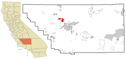
 Location in Kern County and the state of California | |
| Coordinates: 35°30′02″N 119°16′18″W / 35.50056°N 119.27167°W[1] | |
| Country | United States |
| State | California |
| County | Kern |
| Incorporated | January 20, 1938 |
| Named for | William Rufus Shafter |
| Government | |
| • Mayor | Chad Givens |
| • State senator | Melissa Hurtado (D) |
| • Assemblymember | Jasmeet Bains, M.D. (D) |
| • U. S. Rep. | David Valadao (R) |
| Area | |
| • Total | 38.72 sq mi (100.29 km2) |
| • Land | 38.72 sq mi (100.29 km2) |
| • Water | 0.00 sq mi (0.00 km2) 0% |
| Elevation | 348 ft (106 m) |
| Population | |
| • Total | 19,953 |
| • Density | 520/sq mi (200/km2) |
| Time zone | UTC-8 (PST) |
| • Summer (DST) | UTC-7 (PDT) |
| ZIP code | 93263 |
| Area code | 661 |
| FIPS code | 06-71106 |
| GNIS feature IDs | 1661428, 2411873 |
| Website | www.shafter.com |
Shafter is a city in Kern County, California, United States. It is located 18 miles (29 km) west-northwest of Bakersfield.[4] The population was 16,988 at the 2010 census, up from 12,736 at the 2000 census. The city is located along State Route 43. Suburbs of Shafter include Myricks Corner, North Shafter, Smith Corner, and Thomas Lane.
- ^ "Shafter". Geographic Names Information System. United States Geological Survey, United States Department of the Interior. Retrieved November 6, 2014.
- ^ "2019 U.S. Gazetteer Files". United States Census Bureau. Retrieved July 1, 2020.
- ^ "US Census Bureau". www.census.gov. Retrieved August 30, 2024.
- ^ Durham, David L. (1998). California's Geographic Names: A Gazetteer of Historic and Modern Names of the State. Clovis, Calif.: Word Dancer Press. p. 1104. ISBN 1-884995-14-4.

