Shafter, Texas | |
|---|---|
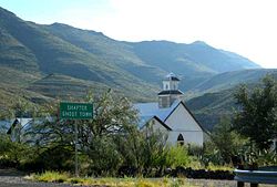
 "Shafter Ghost Town", with Sacred Heart of Jesus Catholic Church | |
| Nickname: Shafter Ghost Town | |
| Coordinates: 29°49′13″N 104°18′12″W / 29.82028°N 104.30333°W | |
| Country | United States |
| State | Texas |
| County | Presidio |
| Elevation | 3,901 ft (1,189 m) |
| Time zone | UTC-6 (Central (CST)) |
| • Summer (DST) | UTC-5 (CDT) |
| ZIP codes | 79843 |
| Area code | 432 |
| GNIS feature ID | 1380523[1] |
Shafter Historic Mining District | |
| Location | 20 mi. N of Presidio on US 67, Shafter, Texas |
|---|---|
| Area | 300 acres (120 ha) |
| NRHP reference No. | 76002058[2] |
| Added to NRHP | May 17, 1976 |
Shafter is a ghost town in Presidio County, Texas, United States. The Texas Attorney General's Office listed a population of 11 as of the 2000 Census.[3] It was named in honor of General William R. Shafter, who at one point commanded the nearby (relatively speaking) Fort Davis.[citation needed] As of 2012, at least one silver mine, La Mina Grande, had been reopened by Aurcana Corporation.[4]
It is listed on the National Register of Historic Places as the Shafter Historic Mining District.
- ^ a b U.S. Geological Survey Geographic Names Information System: Shafter, Texas
- ^ "National Register Information System". National Register of Historic Places. National Park Service. July 9, 2010.
- ^ Texas Attorney General Colonia Data
- ^ MacCormack, John (November 11, 2012). "Water concerns temper elation over Big Bend silver mine". Houston Chronicle. Retrieved November 12, 2012.
