 | |
 | |
| Geography | |
|---|---|
| Coordinates | 53°32′51″S 42°01′12″W / 53.54750°S 42.02000°W |
| Archipelago | South Georgia |
| Area | 20 ha (49 acres) |
| Highest elevation | 75 m (246 ft) |
| Administration | |
| Demographics | |
| Population | 0 |
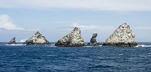
The Shag Rocks (Spanish: Islas Aurora) are six small islets, as opposed to islands,[1] in the westernmost extreme of South Georgia, 240 km (150 mi) west of the main island of South Georgia and 1,000 km (620 mi) off the Falkland Islands.[2] The Shag Rocks are located at 53°32′51″S 42°01′12″W / 53.54750°S 42.02000°W. 16 kilometres (9.9 mi) further southeast is Black Rock, which is located at 53°38′06″S 41°46′30″W / 53.63500°S 41.77500°W.
The Shag Rocks cover a total area of less than 20 hectares (49 acres). Situated on the South Georgia Ridge, they have a peak elevation above sea level of 75 metres (246 ft), and stand in water approximately 319 metres (1,047 ft) deep. Temperatures average −1.2 °C (29.8 °F), rarely climbing above 15 °C (59 °F). There is no significant vegetation, but the rocks are covered by the guano of seabirds. The main wildlife found on the rocks are the South Georgia shags,[3] prions and wandering albatrosses.
- ^ Phillips, Keri (24 July 2014). "Is this a rock or an island? The tiny differences that could define a region". Real Vision. ABC Radio. Retrieved 29 April 2022.
- ^ Headland, Robert (1992). The Island of South Georgia. Google Books: CUP. p. 20. ISBN 9780521424745.
- ^ Burton, Robert; Croxall, John (2012). A Field Guide to the Wildlife of South Georgia. Princeton University Press. p. 15. ISBN 978-0-691-15661-3.