| Shalford | |
|---|---|
| Village | |
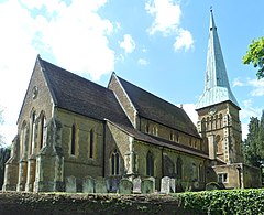
 St Mary the Virgin's Church, Shalford | |
Location within Surrey | |
| Area | 6.51 km2 (2.51 sq mi) |
| Population | 4,142 (Civil Parish 2011)[1] |
| • Density | 636/km2 (1,650/sq mi) |
| OS grid reference | TQ0046 |
| Civil parish |
|
| District | |
| Shire county | |
| Region | |
| Country | England |
| Sovereign state | United Kingdom |
| Post town | Guildford |
| Postcode district | GU4 |
| Dialling code | 01483 |
| Police | Surrey |
| Fire | Surrey |
| Ambulance | South East Coast |
| UK Parliament | |
Shalford is a village and civil parish in the Guildford district, in Surrey, England on the A281 Horsham road immediately south of Guildford. It has a railway station which is between Guildford and Dorking on the Reading to Gatwick Airport line. In 2011 the parish had a population of 4,142.
It has one named locality, occupying the west of the area, Peasmarsh.
Shalford's village sign was designed by Christopher Webb and W H Randall Blacking in 1922, as part of a competition run by the Daily Mail. It shows Saint Christopher carrying the Christ Child over a shallow ford.[2]
- ^ Key Statistics; Quick Statistics: Population Density United Kingdom Census 2011 Office for National Statistics Retrieved 21 November 2013
- ^ "Domain parking page".
